Thursday 28 February 2013

Oxford Calling the ISS

International Space Station over Lincoln
College, Oxford (Credit: Richard Passmore)
Every now and then, I get to see a photograph that just makes me go 'wow.'  One of our graduate students here at Oxford's planetary physics department is a keen and talented photographer, and captured this stunning shot of the International Space Station flying high over one of Oxford's ancient colleges.  The contrast between high technology and centuries of tradition makes this shot particularly exciting, and I asked Richard Passmore if I could share this image online.

Richard had targeted a space station pass at 19:00 on Tuesday February 19th from Lincoln College, Oxford (founded in 1427).  Using a long exposure, the photo captured 69 seconds of the ISS' path before it disappeared from sight.  He had originally planned to capture it in one shot, but the lens wasn’t wide enough to get it all so he created a vertical panorama instead. The sky and building roof was shot at f/3.5, ISO 100 for a duration of 69 seconds (using BULB mode on an SLR).  Richard then re-positioned the tripod to capture the building walls and rest of the quad, this time using an ISO of 1600 and a duration of only 4 seconds (f-stop remained at 3.5).  The brightness on the overlapping regions was fortunately a very good match so when he stitched them together in Adobe Photoshop there were no issues.  Finally he used Adobe Lightroom to correct the colour of the sky (the original image has a very unpleasant orange sky from the city's lights).  The result is great, and it's amazing to think that there are human beings living and working on that tiny star passing overhead.

Britain from space, Credit: ESA/Paolo Nespoili.
Given that Commander Chris Hadfield (https://twitter.com/Cmdr_Hadfield) has been providing some stunning views of Earth from his high vantage point, it's nice to think of us looking right back at him!  On February 21st (two days after Richard's shot), Hadfield captured a nighttime image of Brighton and the surroundings, but I've yet to see an image centred on Oxford from the ISS (hint, hint).  In 2011, Italian astronaut Paolo Nespoili took this photo on a clear night while orbiting 230 miles above Earth aboard the International Space Station, and Oxford is there to the northwest of London along the M40.  On February 13th, Hadfield did get a view of the southern UK at night with Oxford visible, albeit through clouds.   These images from Hadfield have been a real treat, so I encourage you to follow his photo journal on Twitter!

Friday 22 February 2013

What Shall we take to Jupiter? [Updated!]

[Note that this post is now out of date, and full information on the payload for the JUICE mission can be obtained here:  http://sci.esa.int/science-e/www/object/index.cfm?fobjectid=50073]

Yesterday the European Space Agency held a crucial decision meeting for the Jupiter Icy Moons Explorer (JUICE, to be launched to Jupiter in 2022), as part of the 140th meeting of the Science Program Committee (SPC) on February 21-22 2013.  Having spent most of 2012 preparing, writing and submitting a vast range of instrument proposals for JUICE, the Outer Planets community held its breath for the outcome.  Details remain rather hazy, and the decision-making process may never be entirely clear, involving so many national funding agencies vying to get as much as possible for their investments.  The proposals were reviewed by a Payload Review Committee (PRC), an Instrument Review Panel (IRP), and recommendations were sent by the Solar System and Exploration Working Group (SSEWG) and Space Science Advisory Committee (SSAC).   Now that the list has been published, the teams are probably being consolidated and potential new collaborations are being organised - they're almost always multi-national, so agreements have to be forged to ensure that the finance is in guaranteed so that development can get off to a racing start.  The same is true here in the UK, and things are likely to move rather quickly in the next few weeks.
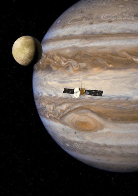
Artists impression of JUICE,
Credit ESA/AOES

Here's a collection of the details we know so far from the ESA and NASA press releases (I'll update these as I learn more):

JANUS: Jovis, Amorum ac Natorum Undique Scrutator, a camera system that certainly wins the prize for the most imaginative acronym.  The instrument, to be built by a consortium  (the principal investigator is P. Palumbo of Naples, Italy, along with R. Jaumann from DLR), is described in a DLR press release here. This camera is destined to map the clouds of Jupiter and the icy surfaces of the satellites in unprecedented detail.

MAJIS: Moons and Jupiter Imaging Spectrometer (led by Y. Langevin of Orsay, France, along with G. Piccioni of INAF, Italy) is a near-infrared imaging spectrometer to be built by an Italian-French consortium, with heritage from Cassini/VIMS, Venus Express/VIRTIS and Juno/JIRAM, among others.  This instrument will provide image cubes of a variety of jovian targets from the visible spectrum to the 5-µm region, and will feature a passive cooler.

UVS: UV Imaging Spectrograph (Randy Gladstone et al.) to be built by the Southwest Research Institute in San Antonio, Texas, and the only US-led instrument on the payload.  This spectrograph will target the surfaces and tenuous atmospheres of the Galilean satellites plus the upper atmosphere and aurorae of the giant planet.  The team is building on their UVS instrument currently on its way to Jupiter aboard the Juno mission.

SWI: Sub-millimetre Wave Instrument (P. Hartogh et al.) is a high-resolution heterodyne spectrometer operating at sub-mm wavelengths to sound fine emission lines from the jovian middle atmosphere and the tenuous sputtered atmospheres of the satellites.  Particularly exciting for Jupiter science, as this will directly measure wind speeds in the stratosphere for the first time, something that's never been done before.  To be built by a consortium based at the Max Planck Institute for Solar System Research (Germany).

GALA: Ganymede Laser Altimeter to map the surface topology of the Galilean satellites, particularly the prime target of the mission (Ganymede).  It will be built by a DLR-led consortium (H. Hussman, Germany) with Japanese collaborators.  GALA is described in a German press release, here, and will use laser pulses reflected from the surfaces to determine the precise heights of features on the moons.

RIME: Radar for Icy Moons Exploration (L. Bruzzone et al., Italy) is a radar sounder to penetrate the icy crusts of the Galilean satellites (to around 5-miles depth, depending on the precise structural composition), to be built by a consortium led by the Universita degli Studi di Trento in Italy.

J-MAG: Magnetometer for JUICE (M. Dougherty et al.) will be a British-built magnetometer led by the team at Imperial College, London and building on extensive heritage from the Cassini magnetometer.  A press release from Imperial describes some of the benefits to this UK institution of being selected to build hardware for JUICE, a prize that many of us had hoped for!  This version does not feature the scalar magnetometer originally proposed.

PEP: Particle Environment Package (S. Barabash et al., Sweden) will study the complex magnetic and charged-particle environment of the jovian system in situ, led by the Swedish Institute of Space Physics and the Swedish National Space Board, with contributions from the John Hopkins Applied Physics Laboratory (including JENI, the Jovian Energetic Neutrals and Ions instrument; and JoEE, an energetic electrons instrument).

RPWI: Radio & Plasma Wave Investigation, led by J.E. Wahlund of Sweden.  This is a reduced package consisting of Langmuir proves (two booms instead of four), a radio wave instrument and a medium frequency radio and density observer.

3GM: Radio science experiment, investigating the gravity & geophysics of Jupiter and Galilean Moons (led by L. Iess of Italy & Stevenson, via @jeanlucmargot).  Features a K-band antenna and ultra-stable oscillator.

PRIDE: Planetary Radio Interferometer & Doppler Experiment (note this does not include spacecraft hardware but will exploit VLBI – Very Large Base Interferometry – to conduct radio science).  This will be led by L. Gurvits of the Netherlands.

From my perspective as a Jupiter atmospheric specialist I'm particularly excited by UVS, MAJIS and SWI, but the most disappointing omission from this list is anything in the thermal infrared, leaving a gaping hole in the spectral coverage beyond 5 µm.  The thermal infrared is crucial if we want to map jovian meteorology (temperature, humidity, composition, clouds and winds), and identify sources of emission and activity on the Galilean satellites.  Its absence comes as a great disappointment for a large number in our community (particularly the 3-4 teams, including Oxford, that spent so much effort on designing such instruments!), but I'm sure we're not alone.  Its absence from the JUICE model payload (which evolved from the Jupiter Ganymede Orbiter) was the primary issue, despite thermal capabilities being a strong element of the original EJSM mission (NASA's Jupiter Europa Orbiter would have carried the thermal-IR mapper).   ESA still has a great mission here, even if it doesn't satisfy everyone, and there always has to be winners and losers in this sort of competition.  It'll be fascinating to watch as the spacecraft develops in the coming months and years.


Thursday 7 February 2013

Final Night on IRTF: Fog and Ice on the Wrong Planet


Cheesy grins in front of the IRTF
It's 5.30 pm and we're up here at IRTF for my final night of observations with TEXES, before flying for home tomorrow.  The TEXES run will continue all the way through until February 11th, but they're only half nights on Jupiter and Io (i.e., 6pm-midnight), so a lot easier on the brain and body than these full nights.  Unfortunately, as soon as I woke up around 2pm I could tell that the weather was going to be a problem - the inversion that normally keeps all the moist maritime air below Hale Pohaku had broken down, and the clouds had surrounded us.  I hiked up a nearby cinder cone, and it was a rather eery experience to be amongst the clouds.  As we drove up to IRTF, we could see clouds over the summit of Mauna Loa, and Haleakala on Maui was completely obscured by thick cumulus clouds.  The  worse news for us was the very high water clouds we could see above Mauna Kea, which will really screw our chances of getting decent observations.  Here's what the forecast says:

Unstable low-level clouds filling in with the northeasterly trades are expected to interact with an upper-level trough passing overhead during the next 24-36 hours. This could saturate the air mass below 15 thousand feet, bringing fog, ice, clouds and/or flurries to the summit over the next 2 nights. Turbulence associated with this trough is also expected to degrade seeing, should observing be possible, during this time. Fortunately, the trough will slip east of the Big Island early Friday morning and a new ridge will fill in from the west around that time as well. This will help stabilize the air mass, push the bulk of the moisture toward the SE, and rebuild the tradewind inversion near 6 thousand feet through that day. This will lead to more normal dry/stable summit-level conditions.

Great sunset with Subaru just opening
in the foreground, February 6th 2013

The high cloud made for a rather spectacular sunset, as it moved below a couple of distinct layers of cloud and took on a deep red colour before it finally vanished.  The air was pretty still, but the clouds were pretty ominous all around us.  IRTF opened its dome, followed by Subaru, but the rest of the summit seemed pretty quiet.  We moved straight to Jupiter, with the plan to spend six hours mapping the planet for Glenn Orton.  With the humidity rising, and the risk of being clouded out, we just shot as many images in eight spectral settings as we could.  It takes about 90 minutes to run through all eight, if there are no hiccups.  Io moved into eclipse from Jupiter's eastern side at 05:40 UT (should reappear on the western side at 08:00 UT), and was a wonderful focusing source for Jupiter.  By 07:20 UT a fog bank had moved in between us in IRTF and the summit ridge, and the humidity spiked up to 95%.  We could tell there were clouds overhead as we were trying to image.

Closing the Dome

Once we reach 95%, we have to close.  We can only reopen once the humidity drops back below 90% for a significant portion of time.  But then the concern is ice build up - I'm told if you go outside and touch the metal handrails, you'll know that it's icing up.  Then you have to wait for the humidity to drop sufficiently for it to sublimate, which can take a while.  Finally, if the ground is cold enough that ice starts forming there too, your night is over.  It's no longer safe to be up here, and we'd head down.  But while we're waiting for all these decision points, we just sit with the dome closed and hope that conditions improve.  I stood outside for a while, and you can feel the moisture on your face, and see that the stars are being obscured.  We waited until near midnight, but there was no improvement, and everything had iced up.  So we took the decision to call it a night, and head back down the mountain.... a shame, but I think we've got some incredible data these past five nights, so I'm not too upset!
The shadow of Mauna Kea at sunrise on
February 6th 2013

Ending the Observing Run

Part of the night was spent strategising over how to publish all the data we've taken, and what our priorities should be in the coming months.  We should be able to produce maps of key meteorological variables on Jupiter (temperature, humidity, winds and cloud cover), measure abundances of isotopic species and hydrocarbons on Saturn, and study atmospheric waves, auroral hotspots and giant storms on both planets.  That's a lot of work for us!

It's been an absolute privilege to work up here at IRTF this week.  I've learned a tremendous amount about TEXES from Tommy Greathouse and John Lacy, and I'm fired up to start analysing data as soon as I return to Oxford.  The experience of being up here on the mountain top is one I'll never forget, and I can understand why Hawaiians believe this 'White Mountain' to be a sacred, special place.  This blog has been a bit of an experiment, so if anyone has read it, I hope you've enjoyed these O2-deprived ramblings from 14000 feet!

Wednesday 6 February 2013

Fourth Night: Io Transit, Galaxies and Laser Guide Stars

After a pretty decent day's-sleep, Tommy, Curtis and I headed back up to IRTF at around 5ish for the fourth night of the observing run.  The clouds were noticeably higher today as we left Hale Pohaku, and checking the weather forecast it seems that things could get pretty dire tomorrow night.  Right now, as I headed out to watch sunset, it's very clear and warm.  I watched as Gemini, UKIRT and Keck all majestically opened their domes, and caught a high-elevation pass of the International Space Station (confirmed transit at 48 degrees elevation at 18:42 HST using the Heavens Above website). We use the Mauna Kea Weather Center to assess what the conditions will be like on a nightly basis:

Although the tradewind inversion is set to slowly breakdown over the next 12-24 hours, it will continue to keep the summit dry and stable for tonight. Unfortunately, there is a strong possibility that it will fall apart by tomorrow afternoon, leading to a fairly saturated atmosphere below 18 thousand feet and likely fog, ice and light flurries at the summit for tomorrow night and perhaps even Thursday night. The inversion is expected to recover near 8 thousand feet by Friday morning.

These inversions are changes in the gradient of the atmospheric temperatures - they tend to trap moist air below the 8000-foot level, leaving the summit dry and clear.  If this inversion is blown away, the trap is no longer effective, hence the forecast of fog, ice and possible snow.  So we're aware that tonight could be our last good shot at Jupiter, Io, Saturn and the galaxies for the next few nights.  Plus we're hearing reports of a magnitude 8 earthquake off the Soloman islands and were worried about tsunamis in Hilo, but it sounds like all is fine on this side of the Pacific.


Moon tracking for the duration of the TEXES run, 
suggesting we'll see Io transit Jupiter tonight.
We shifted the order tonight, starting with Con Tsang's Io program to make sure that we caught Io's anti-Jupiter hemisphere, where the band depths of the sublimated SO2 should be at a maximum.  Io is currently just to the west of Jupiter, heading towards a transit, crossing the disc between 08:00-10:00 UT (our Io observations are from 04:00-08:00 UT), meaning we should see it when we're observing Jupiter's atmosphere.  Callisto is way out to the east, and we're using that as a bright mid-IR divisor to remove the telluric lines from the Io spectrum.  The moon tracking diagram on the right was made using the PDS Moon Tracking Tool.  We're measuring really deep band depths of SO2, which could also be caused by a particularly large eruption on Io's anti-jovian side - Con was online from Boulder and analysing the data for us in real time.  

Next we moved to Jupiter, attempted to do an efficient run through of 8 different spectral settings.  According to Sky and Telescope's handy tool, the GRS should transit the central meridian at 10:14 UT (our Jupiter observations began at 07:15 UT).  It happened right on schedule.  Our settings included the Q-band (for Jupiter's tropospheric temperatures); ethane, acetylene and methane (for stratospheric temperatures), and three low-resolution settings (for ammonia, phosphine and cloud-cover).  The images in the low-resolution settings were stunning - we can make out rings around Oval BA and the GRS, but also the white ovals (WOs) to the south, and interesting morphology on the 5-µm hotspots in the North Equatorial Belt (NEB).  Io was right in the middle of transit at 09:20 UT, but we had to stop our sequence at around 09:45 UT (near midnight) as the airmass was getting so high that the telescope was jittering all over the place.


NASA Hubble Space Telescope image of the
Antennae galaxies (NGC 4038 & 4039) 
Between midnight and 3am we were back observing galaxies.  This time we were measuring the young super star clusters in the Antennae galaxies, regions of star formation in two merging galaxies.  Gas is flowing out of these galaxies at rates far in excess of their escape velocities, powered by massive O stars and Wolf Rayet stars in the clusters.  We're using the neon line to measure the speed of that outflow with TEXES, but the sources are exceedingly dim.  These super star clusters are distributed along the spiral arms and in the region where the two galaxies are interacting.  Tonight we're focussing on getting a scan map of sources B and B1 in NGC4038 (the galaxy on the left).

As we were integrating on these source regions, I took the opportunity to head outside with the night vision goggles for a stunning view of the stars and telescopes, truly breathtaking.  I realised that Keck was using it's adaptive optics system with a laser guide star (e.g, reflecting laser light off a sodium layer 90 km high in the Earth's atmosphere).  A long exposure shot with a Canon DSLR is shown below in black and white to bring out the contrast - the real laser light is red in colour, but is hard to capture with my camera!


Photo of Keck's laser guide star, Orion top left,
Jupiter far right, 11:40 UT on February 6th 2013.
A better image of the Keck guide star from the HEASARC picture of the week.
By 3am we were all getting rather tired, but we were happy that we'd seen the source regions in the Antennae galaxies.  We headed back to Saturn for the final three hours, this time with a focus on CH3D, the deuterated version of methane.  This is present in a much lower abundance than normal methane on all the giant planets, but the ratio of CH3D/CH4 is a great indicator of the deuterium-rich ices that were incorporated into the giant planets as they formed.  Now, I've measured Saturn's D/H ratio before using Cassini CIRS (Fletcher et al., 2009, doi:10.1016/j.icarus.2008.09.019), but CIRS cannot match the spectral resolution  and noise of TEXES in the mid-IR, so we're trying to improve on that measurement.  But Saturn is rather faint - we focus on a region where both methane and CH3D lines are expected, set the guider on IRTF, and just integrate and integrate and integrate until we start to see the spectrum taking shape in our large added spectrum.  The acquisition isn't all that exciting, but at least it isn't too taxing at 3-6am, and hopefully the results will be spectacular!  We finished off with a series of maps, showing Saturn and its rings in all its glory, before closing up after another great night.  Images to follow, I promise!


Volcanoes of Hawaii - Looking Down instead of Up

Taken from the Wikipedia entry, this USGS 
graphic shows the elevation of the islands above 
the sea floor.  PD-USGOV-INTERIOR-USGS.
When you're lucky enough to visit Hawaii on an observing run, you can't help but be awestruck by this rather alien environment of red dusty rocks and limited vegetation.  It's been described as a lunar or martian landscape, and you can really see why.  Mauna Kea is a dormant shield volcano (i.e., one that has grown from accumulated lava flows), having pushed up from  a hotspot beneath the sea floor over hundreds of millions of years, and is the youngest in the chain of 129 volcanoes known as the Hawaiian-Emperor seamount chain, which stretches 3600 miles across the Pacific.  The Hawaiian hotspot is expected to have been stable in the Earth's mantle, with the Pacific plate simply moving over the top to create the Hawaiian islands.  So Kaua'i is the oldest, and a new volcano, the Lōʻihi Seamount, is now forming beneath the sea to our southeast.   Mauna Kea will erupt again someday, but the telescopes up here are so sensitive that there'd be plenty of warning!

The volcano is rather broad due to volcanism in the late stages of its formation, creating a large number of cinder and pumice cones around the summit (individual volcanoes in their own right), rather than one large caldera.  Mauna Kea is the fourth oldest and fourth most active in this chain, but the last eruption was over 4000 years ago, rendering this a stable site for astronomy.  The volcano and its neighbour, Mauna Loa, are so massive that they're actually depressing the sea floor beneath us.  Measured from the sea floor upwards, Mauna Kea is the tallest mountain on Earth at 10.2 km (higher than Everest).

The rocks here are a rich variety of basalts, from a mix of the magma and the subducted ocean floor, all in layers overlying one another, showing the evolution of this mountain.  As we were driving up yesterday, a region of morraine was pointed out to me, these are smaller rocks deposited as an ice-age glacier retreated over the volcano.  This makes Mauna Kea the only Hawaiian island with evidence of glaciation.
Satellite image of volcanic gases escaping from the
caldera of Kilauea in January 2012,  [the crater is known as
Halemaumau Crater] obtained from
 http://earthobservatory.nasa.gov/

As we've driven down the slope of Mauna Kea each morning, we've been reminded just how active this island chain is, as we've seen Kilauea erupting in the distance.  This is a forming shield volcano on the southeastern edge of the Big Island.  I hiked around the quiet caldera last time I was here, but now there's lava in the crater (check out the live webcam of a thermal camera here), and a cloud of ash (known as vog, or volcanic fog) which reflects the red glow, and is visible during the dark hours from Mauna Kea.  This current eruption has actually been happening since 1983, and a few years ago I hiked out across the lava field to see the material running into the ocean.
Screenshot of the thermal-IR view of Halemaumau crater as I write this post, the crater is filled with lava.....

Tuesday 5 February 2013

Third Night: Hitting our Stride

IRTF captured at sunset.

The shadow of Mauna Kea as the sun was setting.
We're now three nights into my time on the summit, and four nights in to the run as a whole.  We've hit our stride now, having ironed out all the various bugs in the first couple of night and tested new settings for the TEXES instrument.  For me, it's been a rather steep learning curve, both for the control of the instrument and for the reduction we're doing in realtime.  The TEXES team have a piece of software called PIPE that we're using the reduce, calibrate and plot the data so we can see it, and that seems to be my main job each night as Tommy Greathouse controls the observations themselves.   John Lacy and Glenn Orton have now left, so there are just a few of us up here each night.

The next few nights fall into a set routine, repeating settings and wavelengths to map our 360 degrees of longitude on a variety of targets, from Jupiter and Io to Saturn.  So we began at 6pm on Jupiter, mapping wave activity in the troposphere and stratosphere using methane and ethane emission bands (we can certainly see waves at mid-latitudes on Jupiter right now).  Then we continued Con Tsang's program of Io observations between 9pm and midnight by observing Io's Jupiter-facing hemisphere, where they expect to see very little SO2 in the atmosphere due to negligible frost and volcanic activity there.  More rather faint galaxy spectra were obtained between midnight and 3am, and then Saturn occupied the final three hours.  Hydrocarbon mapping of the northern hemisphere caught the beacon again for a second night, but this time it was quickly setting on the limb, and had moved off the Earth-facing hemisphere by the end of the night.

At the start of the night I took the car and drove up to the ridge next to Gemini-North to catch the sunset.  It was a lovely evening, with a carpet of clouds laid out below me, and the peaks of Maui in the distance.  I captured images not only of the gorgeous sunset, but also of the shadow of the volcano behind us, rising to a dark peak over the clouds.  During the long integrations on all these targets, we were reducing data from previous nights, and talking about the best ways to calibrate the TEXES dataset (see my separate post here).


What is TEXES Anyway?

[Health warning:  I've made very little attempt to simplify my notes on this... echelons are complicated!]

TEXES stands for the Texas Echelon-cross-Echelle Spectrograph, and is currently a visiting instrument here at the IRTF.  It was first tested on the 2.7-m diameter McDonald Observatory in 1999 before moving to Mauna Kea in 2000.  TEXES measures spectra of astronomical targets between 5 and 25 µm (mid-infrared) in a variety of different modes and spectral resolutions, from a low-res R=2000 mode to an extremely high resolution of R=100000 required for narrow gaseous emission lines.   In my own research, I've found that filtered imaging isn't enough to measure the gaseous composition and vertical temperature structure of a planetary atmosphere, so the natural evolution is to start getting high-resolution spectroscopy in two dimensions.  Hence my proposal to come to Mauna Kea this February.

TEXES mounted on the bottom of the
IRTF, February 2013
The instrument sits in a cold Dewar 1.5 m long, cooled by both a liquid-N2 outer chamber and a liquid-He inner chamber to keep the detectors cold. The LN2 has to be refilled before and after every night of observations, whereas the LHe is refilled once every couple of days.   Light from the telescope enters through a lens at the top of TEXES, reflected through a filter wheel and onto a slit wheel.  The filters are used to select a particular echelle order, and both discrete filters and narrow circular variable filters (CVF) are available.  The slit wheel allows a variety of different slit sizes to be used for a measurement.  After passing through the slit, the light enters the main echelon chamber, where a paraboloid mirror reflects it onto a 90-cm long echelon grating to disperse the light into its constituent wavelengths.  An echelon is effectively a staggered arrangement of plates serving as a diffraction grating, but strictly speaking the diamond-machined grating on TEXES is a grism rather than an echelon.  That dispersed light passes through another cross-dispersion chamber before passing through a reducing lens onto the detector, where it is read out to form the spectra we see in the control room.  The detector is a 256x256 array of SiAs pixels.

Data Reduction

After the data is acquired, the next step is to reduce the raw counts to a useable spectrum.  A room-temperature blackbody (a metal plate, painted black) is moved in front of the lens before each target measurement, and allows us to correct for the response of the detector and achieve a radiance calibration.  By observing the sky, we also measure the location and size of any telluric features in the Earth's own atmospheric spectrum (water, ozone, carbon dioxide) which obscure our view of a target.  Combining the sky with the blackbody observation, we can calibrate the data and reduce the significance of the telluric features.   All this is done by a TEXES data reduction pipeline described by Lacy et al. 2002, (http://arxiv.org/abs/astro-ph/0110521).  Further removal of the tellurics can be achieved by observing a bright mid-infrared target, such as a jovian moon, an asteroid, or a suitable star, although in practise this is rather hard to do.

TEXES can observe in a variety of modes.  Sometimes we simply 'nod' the telescope between the target and the sky.  Other times, we move slightly on the target whenever we return to it, mapping it out over time.  The favoured mode is a scan, taking sky at the start, scanning across an object, and taking sky at the end.  The difference between the target and the sky then gives you your spectrum.  We've used both nod mode and scan mode for Jupiter and Saturn during this run, and the scans will be stitched together later to produce data cubes - i.e., latitude longitude maps with a full spectrum at each position.

Exploring the Summit

View of the telescopes taken from a helicopter
from the north-east, CFHT closest, IRTF & Keck on the right
http://www.ifa.hawaii.edu/images/aerial-tour/aerial-tour.html
The summit of Mauna Kea is host to thirteen telescopes right now, ranging in flavour from the radio to the sub-millimetre and infrared.  They're clustered together in loose groups - five telescopes sit on summit ridge on the eastern side (the Canada-France-Hawaii telescope, or CFHT; Gemini-North; the University of Hawaii 2.2-m telescope; the United Kingdom Infrared Telescope, UKIRT; and an educational telescope for the University of Hawaii).  Driving from east to west, you then come to the Infrared Telescope Facility (IRTF), the twin Keck domes and the Japanese Subaru telescope.  Then lower down from the summit we find the James Clerk Maxwell Telescope (JCMT), the Caltech Sub-Millimetre Observatory (CSO) and the Sub-Millimetre Array (SMA).

Over the last few years we (i.e., outer planet observers) have used several of these observatories, in addition to the IRTF which has been our major workhorse:

Gemini-North and CFHT in the background,
at sunset on Feb 4th 2013
Gemini North features an 8.1-m primary mirror and has been running since 2000, but the UK sadly pulled out of the Gemini science partnership as of the end of last year.  Sometimes the ALTAIR adaptive optics system can be seen using a laser guide star, a beam of light high overhead that allows the telescope to correct for the turbulence of the Earth's atmosphere.  We've used the NIFS instrument in the past to study the clouds of Uranus and Neptune in the near-infrared (e.g., Irwin et al., 2012, http://dx.doi.org/10.1016/j.icarus.2012.05.017), and the MICHELLE mid-infrared instrument to analyse the 2009 impact event on Jupiter (e.g., de Pater et al., 2010, http://dx.doi.org/10.1016/j.icarus.2010.07.010).  Much of these observations are conducted remotely, generating observing routines in large software programs which are then submitted to the night astronomers for execution.

Subaru (left) and the twin Keck telescopes at sunrise
on February 4th 2013.
Subaru is a Japanese 8.2-m telescope that has been operating since 1999, just next to the twin Keck telescopes, and run by the National Astronomical Observatory of Japan.  I've been lucky enough to visit Subaru twice, where the observations are conducted from an office building right next to the dome, but you don't really get to see inside properly.  We've used the mid-infrared instrument Subaru/COMICS (Cooled Mid Infrared Camera and Spectrometer) to track the evolution of giant vortices on Jupiter (e.g., Fletcher et al., 2010, http://dx.doi.org/10.1016/j.icarus.2010.01.005) and the changing polar atmosphere of Neptune (e.g., Orton et al., 2012, http://dx.doi.org/10.1016/j.pss.2011.06.013).

I've never used the twin Keck telescopes directly, but I did get a guided tour back in 2005.  These two domes have the largest mirrors on the summit at 10-m diameter.  Each mirror consists of 36 hexagonal segments which can all move to correct for the atmospheric distortion. There are delay lines in the building between the two domes that allow the two telescopes to be combined to form an interferometer.  I've helped analyse data from the LWS (Long Wave Spectrometer), which was taken off the telescope before I started observing, but my US colleagues have used LWS to detect polar hotspots on Saturn (Orton and Yanamandra-Fisher, 2005, http://dx.doi.org/10.1126/science.1105730) and to get images and spectra of Neptune (de Pater et al., in prep.).
UKIRT at sunset on February 4th 2013

Oxford colleagues have used the 3.8-m UKIRT on several occasions for all four gas giant planets, but that era is sadly coming to an end after the UK shuts down this facility at the end of this year.  UKIRT has been operational since 1979, but since 2010 the telescope has been operating remotely, conducting a deep sky survey (UKIDSS) with the WFCAM instrument (a wide field imager).  Just before it switched to this mode, we used WFCAM to observe the interaction of Jupiter's Oval BA and Great Red Spot in September 2010.  Oxford colleagues Irwin et al. (2010, http://dx.doi.org/10.1016/j.icarus.2010.03.017) had previously used the UIST instrument (0.8-5 µm spectrometer) to study the clouds of Uranus between September 2006 and July 2008, either side of the 2007 equinox.


Second Night: Io's Volcanoes and Saturn's Beacon

View of the IRTF as the sun was setting.
After a brief hike up a cinder cone near to Hale Pohaku, it was time for dinner and the drive up to the IRTF for my second night on the summit.  John Lacy took me out to show me the TEXES instrument, and as he's leaving in the morning it's now my job to help Tommy Greathouse with the liquid-N2 and liquid-He fills to keep the instrument cold.

Jupiter and Volcanic Io

Things were a little windy at first, but we started with 3 hours of Jupiter time between 6pm and 9pm, running Glenn Orton's program to map a set of meteorological variables in the deep atmosphere.  This involved spectra sensitive to tropospheric temperatures, ammonia, phosphine and cloud opacity, all done in medium resolution scan mode, which means we can take spectra with the slit aligned north south and stepped from east to west across the whole planet.  Lots of rifting could be seen on the southern edge of Jupiter's NEB (north equatorial belt), but none of Jupiter's giant vortices were present (the GRS was just rising at the end of this 3-hour section).  But we did spot something really unusual in the southern hemisphere, in the latitude normally occupied by lots of white ovals.  There was a large cold feature, seemingly surrounded by a ring of elevated ammonia, suggestive of some dynamical circulation modulating the ammonia and aerosol fields....  [Correction:  Here's a great example of how O2-deprivation messes with your mind.  Oval BA is currently to the east the GRS, so would rise first.  The GRS transited at 08:35UT, so it makes sense that this rather dramatic southern hemisphere feature was just Oval BA, transiting the central meridian at 07:00UT at a longitude of 210W].

Inside the IRTF dome, showing the full
telescope at zenith.
Next we spent three hours on Con Tsangs and John Spencer's Io observing program.  We were trying to measure the abundance of SO2 in Io's atmosphere to distinguish between sources from SO2 frost or active volcanism on this moon of Jupiter.  More details of these Io observations, which will continue over the next few nights, can be found here.

From midnight until 2.30 am we spent our time looking at starburst regions in galaxies, again trying to measure the gas flows.  We were all getting a little philosophical at this time of night, and on viewing galaxy NGC4194, 129 million light years away from Earth, we notes that the light we're measuring from IRTF right now was emitted from that galaxy during the Cretaceous period, when dinosaurs still walked the Earth.  Pretty profound stuff! But I took this opportunity to head outside to do some long exposure photography of Orion, Ursa Major and the faint Milky Way....

Saturn's Beacon

When I was doing modelling and preparing for this run last month, I used a Cassini observation to predict the location of Saturn's giant stratospheric vortex, nicknamed the beacon, and it should have been right in view between 13:30-14:30 UT (i.e., by about 4am in Hawaii).  So the last three hours of the run were devoted to Saturn and mapping the stratospheric perturbations from the beacon.  We started measuring the powerful ethane emission as the beacon rotated on (spectacular manifolds of emission lines), then moved to methane for an age to try to measure stratospheric temperature, then back to ethane as the beacon was right on the central meridian (right on schedule, too!), before finishing with scans for acetylene and ethylene as the beacon was setting.  All these hydrocarbons are expected to be perturbed by the unusual chemistry within the vortex, to varying degrees, so we'll have to model these spectra to see what's really going on.
Watching the Saturn beacon data roll in....

One of the nice things about the ethane lines, apart from being fast, is that they show Saturn's rapid rotation too.  As we have the pixels aligned north-to-south, but move them east to west, we see the lines Doppler shifted towards us on the western limb and away from us on the eastern limb, as Saturn rotates west to east, just like on Earth.  You can actually see the lines moving in the spectra because Saturn is spinning!

Our last job of the night was a refill of the liquid helium and liquid nitrogen.... I've never played with liquid so cold before, and it took about an hour for us to transfer it into the dewar that surrounds TEXES, so the sun was well above the horizon by the time we headed down for breakfast.


View towards the west, showing the Keck domes after sunset.

Monday 4 February 2013

Mapping Io's Atmosphere from TEXES

One neat thing I've been able to do on this run is take part on observations that are nothing to do with my Saturn proposal.  One of those is a proposal from Con Tsang and John Spencer of the Southwest Research Institute in Boulder, CO, to monitor the amount of SO2 in the tenuous atmosphere of Io.  Io's volcanoes are belching out this sulphurous material, which falls to the satellites surface and condenses as an SO2 frost.  Their TEXES measurements in 2001, 2002 and 2004 showed that the amount of SO2 in the atmosphere varies with Io longitude - there's more over the anti-jovian hemisphere than there is on the side facing Jupiter (Spencer et al., 2005, doi:10.1016/j.icarus.2005.01.019).  There could be two explanations for this - firstly, there's a larger concentration of Io volcanoes on that side of the satellite, so this could be a sensor for that volcanic activity.  But it could also just be a measurement of the rate of SO2 frost sublimating into the atmosphere, and there's more frost from those volcanoes on the anti-jovian side.  Tsang et al. 2012 (doi:10.1016/j.icarus.2011.11.005) added in even more TEXES data to fit this same complex of SO2 lines at 530 cm-1 (19 microns), covering 2001-2010, and found that the amount of SO2 varied with time, being more abundant when Jupiter was closer to the sun (perihelion), supporting the idea that Io's atmosphere is at least partially supported by frost sublimation.

Map of Io, centred on the anti-jovian point (180 degrees longitude), showing some of the major volcanic features.  The images were compiled here:  http://www.britastro.org/jupiter/moonmaps.htm

The point of these Io observations over the next few nights is to get a new map of Io's SO2 distribution, and to see if the atmosphere has shown signs of deflation after perihelion (March 2011, when presumably SO2 evaporation was at the highest rate). Io goes around Jupiter once every 1.8 days, meaning that a sequence of consecutive nights will allow us to map most of the longitudes to see if the contrasts have changed with time.  The hope is that this will differentiate between atmospheric support from volcanic injection, or from frost sublimation....  but the suspicion from Tsang et al. is that there must be at least a little volcanic injection, given that they saw SO2 in the atmosphere still during the aphelion.  Con and John were both following along remotely, so I'm sure they'll have their work cut out in analysing this new TEXES Io dataset!


Observing at NASA Infrared Telescope Facility

Why Mauna Kea?

A combination of factors make the summit of Mauna Kea on the Big Island of Hawaii ideal for planetary observing, particularly in the infrared.  The altitude means that the amount of water vapour above the telescope is low (water is opaque in the infrared so you can't see through it), plus an inversion layer sits below us that keeps the moist cloud cover well beneath the observatories.  The air here is also really stable, limiting the atmospheric turbulence that degrades seeing, which means the stars don't 'twinkle' as much as they do elsewhere.  We're also well away from any towns or cities, meaning that the skies are clearer than I've ever seen them.  All this means that there are thirteen observatories of different flavours, from the optical to the radio, sat up here on the summit of an extinct volcano.

Infrared Telescope Facility

Sunset over IRTF on February 4th 2013
Our workhorse for planetary astronomy has always been the Infrared Telescope Facility (IRTF), operated by the University of Hawaii under an agreement with NASA.  It features a 3-m diameter primary mirror with a classical Cassegrain telescope, so light bounces off the primary mirror, back to the top to a small secondary mirror, before being focussed onto whatever instrument is pushed into the MOM (multiple instrument mount), which allows different instruments to be slid into place.  The telescope is mounted on a large, heavy English yoke equatorial mount (the yellow thing in the pictures) to limit sensitivity to any vibrations.  The observatory was constructed in the late 1970s to support the Voyager missions to the outer solar system, and has since been used to support many planetary missions (Galileo, New Horizons, Cassini) and for the Shoemaker-Levy 9 impact back in 1994.  About 50% of its observing time is dedicated to planetary astronomy.

The telescope and dome before the start of our run.

Inside the Control Room

The observers and telescope operator tend to work a 12-hour night, coming up at 6pm as the sun sets and then heading back down at 6am, or thereabouts.  The telescope operator is in control of the telescope and where its pointing (i.e., what target, and whether we use stars to guide the telescope for added stability on the target), and sits at a large control panel in front of a big window looking into the dome itself (blacked out when we're actually observing).  The observers then sit at a series of computer terminals on the other side of the room, controlling the instruments themselves.  The instrument can make small corrections of a few arcseconds to move the target around on the arrays (i.e., for subtraction of background emission or bad pixels from the final images), but most of our time is spent setting up the wavelengths of interest, moving filters in and out, deciding how long to integrate for to get clean-looking spectra, and which spectral settings are needed to achieve the desired science.

Inside the control room, observing Jupiter.
When we observe with a visitor instrument such as TEXES, the instrument specialists (this time John Lacy and Tommy Greathouse) arrived early to start cooling the instrument with liquid nitrogen and liquid helium down to the optimum temperatures of 4K (i.e., 4 degrees above absolute zero), and to ensure everything is mounted and working properly.  Each morning and night we add more liquid N2 to the dewar to keep things cool, and top up the (very expensive) liquid helium once every other morning.  Then we come into the control room, sit down at the terminals, and start to run through the pre-planned targets and spectral settings (this time mostly Jupiter and Saturn, with some Io and starburst galaxies thrown in too).  Some of the terminals are for operating TEXES, others are for transfering data between discs, and another is used Here we stay, staying hydrated (and for some of us, caffeinated) for the night, and trying to keep each other awake during the longer integrations when we're just sat adding up photons from dim sources, or executing mapping procedures.  Hale Pohaku prepare bagged 'night lunches' for us to stave off the hunger.  At the end of the night the instrument is shut down, the dome closed and the telescope yoke returned to zenith, and we all head down to get some much needed sleep!

Hale Pohaku, the Stone House

Hale Pohaku from the top of a nearby cinder
cone, February 4th 2013
When astronomers head to Hawaii for their observing runs, they don't spend their whole time up at the summit.  They eat, sleep and acclimatise at the 9000-ft level in a specially-designed residence called Hale Pohaku.  Centred around a big, open dining room with views out to the south between Mauna Kea and Mauna Loa, the main building contains offices, a library, TV room, games room and various places to relax when we're not on sky.  There are then four dormitory rooms, and the Onizuka Visitor Center back down the hill.  It's extremely dry up at this altitude, so all the rooms have humidifiers that tend to run most of the day, and black-out blinds so that we can get some sleep when the sun is blazing in the cloudless sky.

The outside of the dorms at HP.
One of the original stone houses.
The name Hale Pohaku means 'House of Stone' in Hawaiian, and is named after some stone cabins that were built here in the 1930s to house members of the civilian conservation corps while they were installing forest reserve boundary fences on the volcano flanks.  The current buildings date from 1983.  Although I didn't spot any on my stay, Hale Pohaku shares its location with a range of native Hawaiian birds, and apparently you'll sometimes see goats, sheep and wild pigs wandering around the dusty old cinder cones.  The closest cinder cone is visible just out my window, and is called Pu'u Kalepeamoa, and was apparently known for its lava bombs, used by the locals as fishing weights.


The upper areas of the volcano are considered by native Hawaiians to be sacred, and at the very summit there are a range of small flowers and gifts left as offerings.  The Humu'ula trail runs by the Hale Pohaku lodging, all the way to the summit via a quarry and Lake Waiau.  I hiked down the trail once, in 2005, after a long night of observing and in need of fresh air, but managed to get sunburnt from the light reflected off the snow as we hiked down.

Sunday 3 February 2013

First Night on Sky: Jovian Waves and Saturn's Composition

The view of Mauna Kea from Saddle Road,
with one of the domes visible on top.
Awake at 4.30, quick dinner in HP then a steep drive up a dusty road to the summit of Mauna Kea.  Beautiful views over the saddle to Mauna Loa, and a wonderful clear blue sky as the sun sets over the clouds below us, but we all disappear into the Infrared Telescope Facilities operating room for the next 12 hours.  The transition from sea level to the summit is pretty tough to do in a day, and I spend the first hour or two with a metallic taste in the back of my mouth, a sign that my brain isn't getting it's usual oxygen rush!  But once you get used to it, stay hydrated and start thinking about the problems at hand, it's really not that hard.

Jupiter's Waves and Aurora

The run actually started yesterday, on February 1st, with Tommy Greathouse's program of Jupiter observations.  TEXES is an exceptionally high-resolution spectrometer (I'll try to blog about the instrument at some later point), and measures spectra in very small chunks.  So we pick a couple of ranges where we know that (i) the spectral lines from Jupiter are strong and useful for probing the atmospheric temperatures; and (ii) the atmosphere of our own planet is transparent enough for us to see through without hindrance.  We pick lines of ethane and methane, as this permits us to measure the temperatures of Jupiters stratosphere.  In addition, the smooth continuum spectrum in between the forest of ethane is actually sensitive to the tropospheric temperature, so we can map both troposphere and stratosphere at the same time.

Looking at the IRTF secondary mirror (dead centre).


Tommy's program is to get a full 360 degrees of longitude on Jupiter to search for wave activity in the jovian tropics.  There's all sorts of waves here, including horizontal slowly moving waves that could be related to weather events below, plus vertically propagating waves known as Jupiter's quasi-quadrennial oscillation by analogy to the quasi-biennial oscillation we have in Earth's atmosphere.  TEXES can see all of them, and map them out in three dimensions (i.e., horizontally, and with height in the atmosphere above the jovian cloud tops).  As Jupiter rotates once every ten hours, but is only available to the telescope for a few hours in a night (6 hours at the moment), we need at least two consecutive nights to map a complete longitude circle.  So they started yesterday while I was sleeping in Hilo, and we continued tonight under stunning weather conditions - clear skies, low humidity, low winds, just a perfect observing run.

A view inside the IRTF control room, where
our entire night was spent

The ethane and methane emission maps were built up by scanning the instrument over the planet, aligning the entrance slit north to south, and then stepping it from east to west, taking an observation every 0.7 arcseconds (Jupiter is 43 arcseconds across right now) to get the longitude coverage.  We also step from north pole to south pole to get latitudinal coverage, meaning that we get the tropical and equatorial oscillations that we're after, plus glimpses of the hotspots associated with heating in Jupiter's auroral regions.  We clearly saw the high temperatures of first the south, then the north auroral hotspots.  This dataset will now be reduced to track all this wave activity, and we'll repeat the observations in a week or so to see if any of these features are moving and shifting with time.  So from 6pm to midnight we got plenty of excellent Jupiter data, moving back and forth as the planet rotated beneath us, now it's time for come caffeine until Saturn rises at 3am.....

Saturn's Composition


Once Jupiter was setting into the murk at around midnight, we spent a few hours observing starburst galaxies to study gas flow velocities, before getting to where I really wanted to be.  My proposal to come to Hawaii had centred around capturing Saturn's beacon (see earlier post), but as that won't be on the right side of Saturn until tomorrow night, we had plenty of other projects we could execute.  My top priority addresses the question of Saturn's ammonia abundance.  The Cassini spacecraft struggles to measure ammonia in the mid-infrared because of a low sensitivity in the required spectral regions.  TEXES, on the other hand, has no such problems.  So we tried something that had been rarely done before, choosing the lowest resolution mode of TEXES so that we captured as wide a spectral region as possible.  This works nicely for tropospheric features like Saturn's ammonia (the key species forming its clouds and hazes) and phosphine (a gas thought to be dredged up from deep within the troposphere, beneath the clouds), as they both have extremely broad lines.

It took us a little playing to make sure the spectral setting was right, and took us simultaneously acquiring, reducing and modelling the data, all at 13,000 ft and at 3am in the morning, to make sure we were getting the right thing.  But when we started taking data, we realised we could see lines of both phosphine and ammonia straight away.  Furthermore, by observing for as long as we could as Saturn rose in the sky, we could separate the signal from the noise sources to get a beautifully clean looking spectrum of ammonia and phosphine lines.  The weather conditions remained perfect for this, as we just added more and more data racing until 6am in the morning.
Tommy Greathouse and Glenn Orton controlling
the TEXES instrument and telescope.

Having a clean spectrum will be a huge step towards one measurement I've been after for ages now, and Cassini simply can't do it.  That's measuring the relative abundances of two versions of ammonia, NH3, in Saturn's atmosphere.  One version has a slightly heavier isotope of nitrogen than the other.  The trouble is, the amount of the heavier isotope is around a thousand times less than the lighter isotope.  Hence the need for a really good spectrum, to see the heavier isotope.  If we can measure that ratio, it tells us something about how the planet formed, particularly where it got all of its nitrogen from.  It's been done on Jupiter by Cassini in 2000, but there's so much more ammonia there than on Saturn, where the spectral features are normally all completely obscured by phosphine.  So, I've now got my work cut out for me, but my first night of TEXES observing has provided enough spectral data for some fascinating science.

Now my sleep-deprived brain needs to shut down and sleep.....  it's 5.45am, we're moving the telescope to zenith and closing up.  Superb night.

A long exposure view back across at the Keck telescopes, with Jupiter setting in the east.
You can just see Subaru in the distance too.


Saturday 2 February 2013

Chasing the Sun to Hilo

The Banyan trees of Hilo....
The Japanese gardens.
The last leg of the journey, from LA to Hilo on the Big Island, was certainly the most gruelling. As I took off from LAX, I watched the red sky of the sun setting as we flew out over the Pacific, chasing sunset west around the planet.  I finally made it to Uncle Billy's Hilo Bay hotel around 10ish local time, only to be awake again ridiculously early.   Amazingly, the sun was shining on Hilo, so I took off to soak up some of the humidity before driving up the the summit (where, I'm told, humidity is currently hovering around the 1% level, perfect for observing).  I wandered to Coconut Island for a view back across the bay to Downtown Hilo, then via the Japanese Gardens and along the bay drive to the town centre.  I took a leaf out of a Frommers guidebook and did a half-hour walking tour around downtown, seeing some of the buildings that survived the onslaught of Hilo's two tsunamis last century.  I stumbled across the Hilo Farmers Market, which was packed with people at 8.30 am and glistening with fresh Hawaiian produce and flowers, before wandering back to the hotel as the Sun rose higher in the sky.

Then it was back on the road to climb 4.2 km into the sky up the flanks of Mauna Kea....


Looking up into a Banyan tree

Looking Back – The New Horizons Jupiter Encounter (2007)


Six years ago, I was in the final year of work on my PhD in Oxford and was awarded funding by the UK’s Particle Physics and Astronomy Research Council (PPARC) to participate in another giant planet observing run at NASA’s IRTF.  Before leaving, I dredged up my notes on that last trip to remind myself of some of the technical details, and it brought back a whole host of memories.  New Horizons, still hurtling towards Pluto for its close encounter, was at that point approaching Jupiter, and we’d secured time on both the IRTF and Subaru to provide contextual infrared observations of Jupiter during the flyby.  Unlike this flight, that time (February 25th 2007) I had a window seat all the way, and watched the plane’s vapour trail shadow over the pristine snow of Iceland, as well as some daunting and towering clouds over the summit of Mauna Kea as we looped to the north of the Big Island.  Apparently it had been raining on the island for days.  Water poured off the flanks of Mauna Kea as we drove along the Saddle Road to Hale Pohaku, the astronomers quarters at 10’000 feet.

As soon as I arrived I started to hear dire reports about the snowed-in summit.  Chains were required on the wheels, and when I rose at midnight on February 28th, we were told that our Subaru time was cancelled – the technicians had heard the sound of ice cracking as they opened the telescope dome, so had cautiously cancelled all the observations.  We finally headed up to the summit at 5am for some pre-dawn observations from the IRTF, but of the three usual instruments we use, one was too warm, one was too cold, and the other wasn’t exactly ideal for the science we wanted to achieve during the flyby.  However, the images at 5 microns were eventually used by Baines et al. (2007) (DOI: 10.1126/science.1147912) in a study of Jupiter’s cloud variability, and we also caught glimpses of Jupiter’s Oval BA from the Very Large Telescope via some remote observations, which later formed a part of a detailed New Horizons study by Cheng et al. 2008 (doi:10.1088/0004-6256/135/6/2446). 

To our disappointment, our second night of observing was also cancelled due to high humidity and fog at the summit, but the following night yielded some more nice results from the MIRSI infrared instrument that were also used in later publications.  Tom Stallard and Mackenzie Lystrup were also on Mauna Kea to use another instrument, CSHELL, so I spent an additional night with them learning the ropes and observing jovian aurora at high spectral resolution.  My last full night, March 3rd, was devoted to infrared observations of Saturn, and we were all really excited to see the return of cold 5-µm structures in Saturn’s deep cloud decks.  So despite a catalogue of errors at the start of the 5-night run, by the end we’d got a valuable dataset to support the New Horizons flyby, and some new Saturn data to support Cassini’s ongoing exploration, so I left Mauna Kea happy.

Unlike in 2013, back in 2007 I had time to explore Hawaii for a week afterwards, accompanied by an old uni friend of mine.  We visited the volcano park, and hiked some of the way out to where erupting Kileuaea was spewing lava into the sea.  We headed for the solidified lava lake of Kileuau Iki, and hiked down through the rainforest and onto the solidified lava floor, stopping to see the steam vents and visiting the Thurston lava tube on our way back out of the crater.  We kayaked on Kealakeua Bay, where Captain Cook had first ‘discovered’ Hawaii in 1778, and sailed across to the monument that stands where the locals ultimately killed Cook.  We flew on to Maui, and spent a great day snorkeling near Lahaina, took a trip to see humpback whales during their breeding season; then wine tasting on the slopes of Haleakala before driving to the summit to look back across to the bulks of Mauna Kea and Mauna Loa to the southeast.  Finally we flew on to Oahu for a final night out in Waikiki before the end of a superb trip.  The Hawaiian islands are truly beautiful places, I hope I get to take my family someday.  But there’ll be none of that on this trip.  This time, it’s all about the observing run.  So, from a bar in LAX at midnight (my time), onwards to Hilo....