First the basics: Europa is a highly evolved world, with a low crater frequency implying a young age of the surface material (as low as 60 million years). That youth is inherently linked to the ocean and gravitational tides, which trigger resurfacing, cracking and release of fresh materials from the interior. We expect a metallic core, a silicate rock mantle, and then an outer layer of water ice some 100-200 km thick, some of which is a salty liquid (evidenced from the induced magnetic response to Jupiter’s magnetic field). The ice shell above the liquid might be 10-30 km thick (from morphological studies of landforms), although it might be as thin as 3 km in some regions. The ice penetrating radar should be able to help us resolve that mystery.
Dark mottled terrain dominates the trailing hemisphere, with ridges and double ridges hundreds of kilometres long being the most ubiquitous landform. The darker terrains are associated with materials like salts, sulphates, carbonates and/or sulphuric acid on the surface, whereas brighter areas are richer in water ice. The trailing hemisphere appears brighter, possibly as a result of the more modest particle bombardment compared to the trailing hemisphere. The main process shaping the surface appears to have been tectonism, with tidal stress (from Europa's 85-hour period for orbiting Jupiter) generating linear ridged plains with dark bands, which subsequently evolved through faulting to create the chaotic terrains at lower latitudes. However, the mechanisms creating specific features remain highly uncertain, and surface features could be linked to the sub-surface ocean, tidal effects and possible exchange processes.
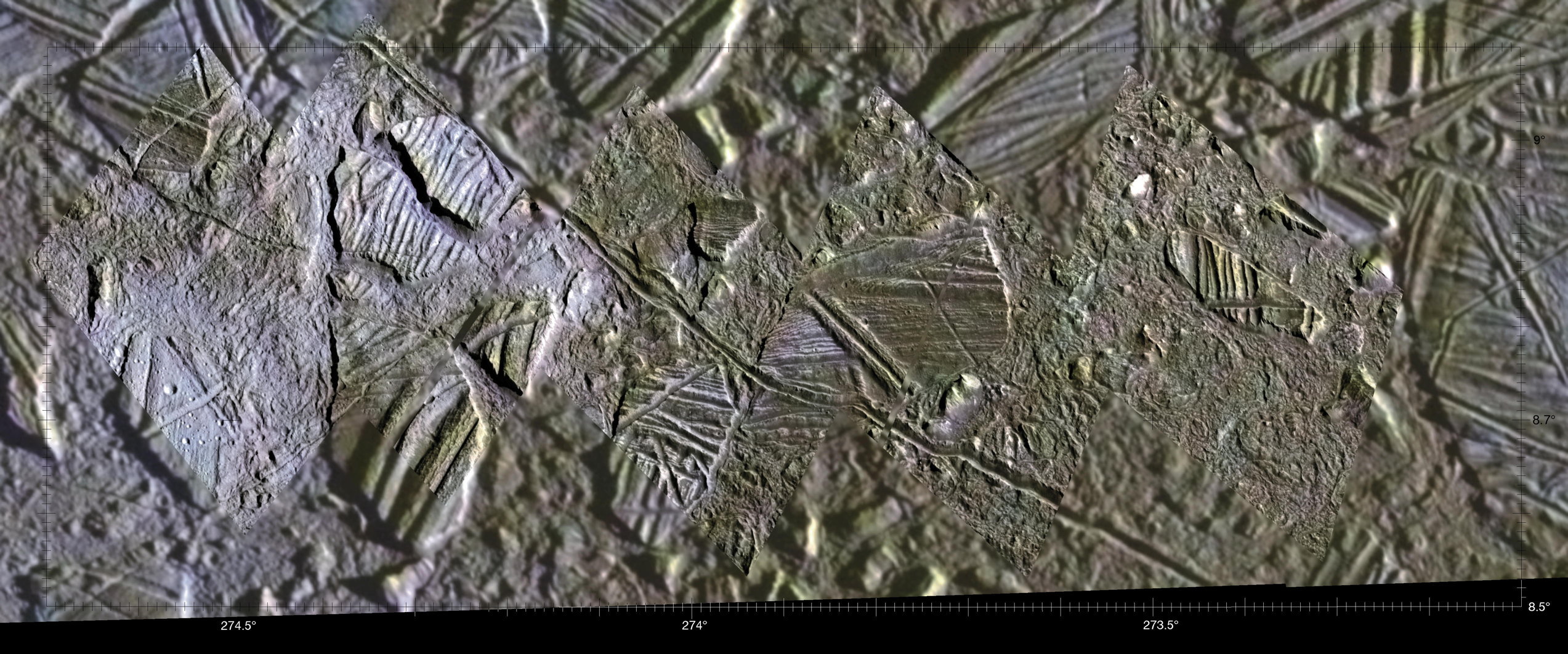
Only 10% of Europa’s surface was imaged by Galileo at a resolution of better than 100 m, and Europa remains poorly imaged at regional resolutions of 200-500 m. The highest resolution image obtained by Galileo was at 6m/pixel, revealing the surface to be extremely rough at small scales, but this was only done once. The JUICE team selected eight regions of interest for their geological, chemical and astrobiological significance, and then designed the flybys to give close views of these locations. I’ll try to summarise each of those regions below - the Regio, the disrupted terrains, linear features and impact craters.
 |
| Regions of interest for JUICE, with the darker mottled areas known as Regio. Ground-tracks for the two flybys are shown. Credit: ESA Red Book. |
1. Regio: Darker Terrains:
At low spatial resolution, Europa’s Regio are locations of darker terrain and are given names from Celtic mythology. On the trailiing side during the approach phases JUICE will be able to observe Annwn (20N, 40E), Argadnel (15S, 151E), Dyfed (10N, 110E), Falga (30N, 150E) and Moytura (50S, 65E) Regio. On the leading side, JUICE will observe Balgatan (50S, 330E), Powys (0N, 215E) and Tara (10S, 285E) Regio during the departure phases.2. Disrupted Terrain: Chaos and Lenticulae
 |
| Conomara Chaos from Galileo. |
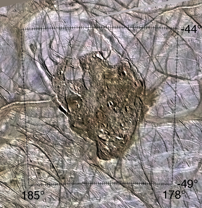
Fractured plates of ice that have shifted with respect to one another, possibly due to localised melting of the salty ice shell due to ice convection or oceanic plumes, form the jigsaw of the chaos terrains. The chaos rafts show pre-existing ridged plains that have been broken up. Some chaos units appear to stand higher than the surrounding terrain, whereas other appear to have foundered into a finer-grained material. Reddish material is associated with the chaotic terrain, possibly hinting at a relationship with the deeper ocean. JUICE will be able to investigate the Conamara Chaos region (A3, 8N, 85E) that has previously been explored by Galileo, but will additionally study chaos terrains in the central and northern parts of the Dyfed Regio region (B1e, B1b, B1c) associated to Conomara, where the activity has disrupted the Asterius, Glaukos, Agave and Belus Linea.
 |
| Thera Macula, from Paul Schenk's Atlas of the Galilean satellites. |
These two features, enriched in dark materials potentially emplaced in a liquid state, were considered the highest priority for the flyby. Thrace is the largest of the Maculae at 180 km diameter, Thera is only 95 km wide. Here we find chaos material with a matrix of pre-existing structure associated with dark plains, possibly with emplacement of liquid via some sort of cryovolcanism. Three other Maculae (Boeotia, Castalia and Cyclades) are found in the southern hemisphere (54, 2 and 64S, respectively) around the antijovian point. The inset region of Thrace was imaged by Galileo at 40m per pixel, the rest of the image has a scale of 250m.
Lenticulae (A5, 45N, 145E):
Pits, spots and domes all suggest ice shell convection and are found throughout Europa’s mottled terrain. These relatively recent circular/elliptical domes and pits (10-15 km across) are associated with prominent intersecting ridges Minos, Udeaus and Cadmus Linea. Within the domes there is a texture referred to as ‘microchaos’. Their possible origin is from upwelling of warm, ductile ice, with evidence of melting and exchange with the subsurface.
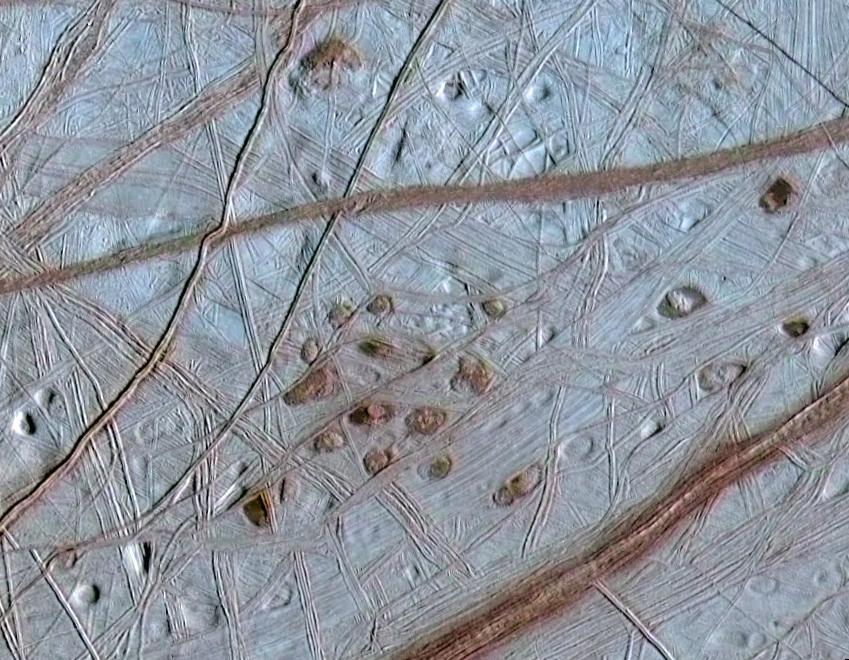 |
| Lenticulae (Latin for 'freckles') on Europa. NASA / JPL / University of Arizona / University of Colorado |
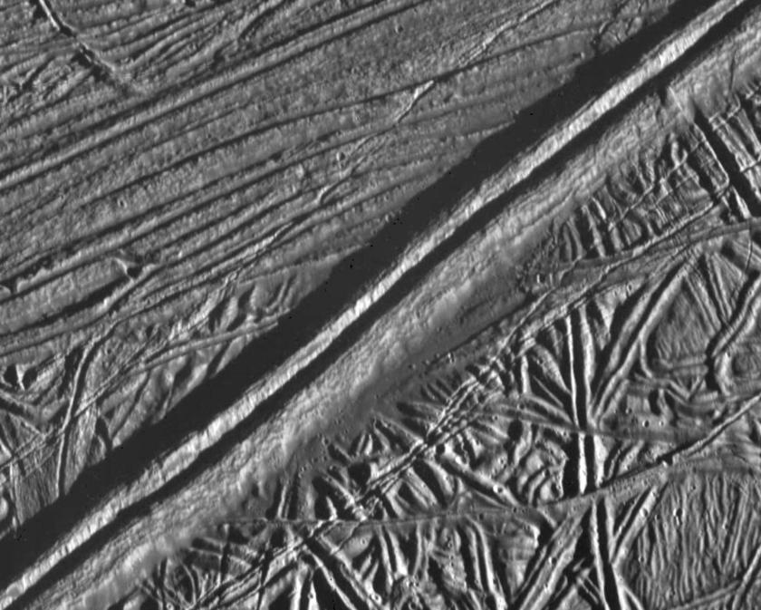
3. Linear Ridges, Bands and Fractures
Linear features cross Europa’s surface for hundreds of kilometres, possibly due to fracturing of the icy crust. Ridges have widths as wide as 2 km and can be several hundred metres high. Some are double structures separated by a central trough; some are cycloidal and form chains of arcs.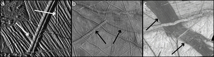 |
| Three common morphologies of linear features on Europa (a) trough (b) ridge (c) band. NASA / JPL / Marshall and Kattenhorn |
 |
| Double ridge on Europa, Feb 1997, NASA / JPL / ASU |
Ridged Plains (8S, 140E)
Complex network of ridges, bands and chaos. Double ridges could form from extrusion or intrusion of water or warm ice, with frictional shear heating from motions (strike-slip faults) along fractures causing warming and melting, creating mobile ice to squeeze through fractures to form the ridge. Bands could be formed by the pulling apart of the crust by separation and spreading.
Band Wedges (A6, 5S, 160E):
These appear to be lineaments that were opened, separated and then filled by a darker (low albedo) non-ice material, much like sea-floor spreading on the Earth. These wedge-shaped pull-apart bands provide evidence for the original configuration of the ice before the surface began to move. The youngest bands tend to be the darkest, whereas older bands are bright.
Fractures
Fractures are narrower than the ridges and bands, and are seen down to the 10-m resolution limit of the best images to date. They can exceed 1000 km in length, cutting across nearly all other features to suggest that deformation of the ice shell occurs over short timescales. The youngest fractures could even be active today, in response to tidal flexing.
 |
| Pwyll crater with bright rays, NASA/JPL/Arizona |
4. Impact features:
Only 24 impact craters larger than 10km in diameter have been identified on Europa, providing strong evidence for a youthful surface. Taliesin (22S, 222E) is the largest at 50 km diameter, followed by bright Pwyll at 45km diameter. Multi-ring structures from an impact, can provide information about the physical properties of the sub-surface. There are very few large craters on the surface, hinting at an age of around 60 million years. Pwyll on the trailing hemisphere (25S, 89E), named for the Celtic god of the underworld, is the most striking of the impact features, and the bright rays suggests it formed less than 5 million years ago. Pwyll is shallow and relaxed. Multi-ring structures like Tyre (34N, 214E) suggest that the impactor punched through 20-km thick ice, with a central peak from a rebound and surrounded by faulting.More details of these features can be found in the Gazetteer of Planetary Nomenclature maintained by the USGS:
http://planetarynames.wr.usgs.gov/Page/EUROPA/target
No comments:
Post a Comment